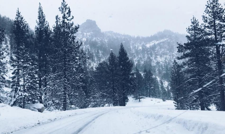

A winter storm bringing heavy snow, dangerous road conditions and high avalanche danger to Northern Nevada prompted delayed openings Thursday for state government offices, Carson City schools and Western Nevada College, as forecasters warned of additional snowfall across the region and up to 30 inches in the higher Sierra elevations.
The National Weather Service in Reno has issued a winter weather advisory for the greater Reno-Carson City-Minden area through 7 p.m. Thursday, Nov. 19, with snow expected to affect both the morning and evening commutes.
A winter storm warning remains in effect for the greater Lake Tahoe area through 4 a.m. Friday, where heavy snowfall and winds gusting as high as 100 mph along Sierra ridgelines are creating hazardous conditions. A separate backcountry avalanche warning is also in effect for the central Sierra Nevada.
State government offices delayed
In response to winter weather advisories, Gov. Joe Lombardo ordered a two-hour delayed opening for state government offices in Carson City and Douglas, Elko, Humboldt, Storey and Washoe counties.
Affected offices will open at 10 a.m. Thursday. The delay does not apply to essential public safety and corrections personnel.
Carson City schools on two-hour delay
The Carson City School District announced that all district schools will operate on a two-hour delayed schedule Thursday.
School buses will run approximately two hours later than their normal schedules, with alternate bus stops, also known as snow stops, in effect.
The district said buses will pick up and drop off students at designated alternate stops along streets that can be safely accessed during winter weather.
Early childhood and prekindergarten classes are canceled for the day, and breakfast will not be served at schools.
Despite the delayed start, students will be dismissed at their regularly scheduled times.
District employees have been asked to report to work at least 30 minutes, but no more than 45 minutes, before student instruction begins to allow time to prepare parking lots and walkways.
The district urged employees to use caution and plan for travel times that could be twice as long as normal, depending on road conditions.
Parents are encouraged to dress students appropriately for cold and wet weather and monitor the district’s website at carsoncityschools.com for updates.
Washoe County
The Washoe County School District announced a two-hour delayed start for all schools Thursday, except those in Incline Village, where classes are canceled because of hazardous weather and road conditions.
Winter bus stops are in effect throughout the district, and morning half-day programs are canceled.
Truckee Meadows Community College will operate remotely until 11 a.m., when in-person classes and services are scheduled to resume. The University of Nevada, Reno delayed nonessential campus operations until 10 a.m., with in-person classes before that time canceled.
Douglas County
The National Weather Service has issued winter weather advisories through 7 p.m. Thursday for the Reno area and northern Washoe County, with additional snowfall expected in valley and mountain communities.
Winter weather has prompted a two-hour delayed start Thursday for Douglas County School District schools at Lake Tahoe, with alternate snow bus stops in effect.
State government offices in Douglas County are also operating on a two-hour delay under an order issued by Gov. Joe Lombardo, with affected offices opening at 10 a.m.
The National Weather Service has issued a winter weather advisory for the Carson Valley area through 7 p.m. Thursday. Additional snow accumulations of up to 3 inches are possible below 5,000 feet, with 2 to 6 inches above that elevation.
Conditions are expected to be more severe in the Lake Tahoe portion of Douglas County, where a winter storm warning remains in effect through 4 a.m. Friday.
Lyon County
Snow and rain are expected across Lyon County Thursday, with the National Weather Service forecasting varying conditions between northern and southern portions of the county.
In northern Lyon County, including Fernley and Silver Springs, forecasters expect snow and rain with accumulations of up to 2 inches Thursday. Additional snowfall of up to 2 inches is possible Thursday night as snow levels drop toward the valley floor.
In southern Lyon County, including Yerington and Smith Valley, forecasters expect a mixture of rain and snow, with accumulations of 1 to 3 inches Thursday.
Snow and rain could create slippery conditions on area roads, particularly as temperatures drop Thursday night.
Storey County
All Storey County School District schools are closed Thursday because of winter weather, following an initial announcement that classes would begin two hours late.
The closure comes as a winter weather advisory remains in effect for the greater Reno-Carson City-Minden area, including Virginia City, through 7 p.m. Thursday.
The National Weather Service forecasts an additional 2 to 6 inches of snow above 5,000 feet, with locally up to 10 inches possible at elevations above 6,000 feet.
State government offices in Storey County are also affected by Gov. Joe Lombardo’s two-hour delayed opening order, with nonessential offices scheduled to open at 10 a.m.
Motorists are urged to use caution as snow and slippery roads could affect travel throughout the day.
Western Nevada College delays Carson City campus opening
Western Nevada College announced that its Carson City campus, including the Child Development Center, will open at 10 a.m. Thursday because of hazardous winter weather conditions.
The college’s Fallon campus will maintain its regular operating schedule.
Students attending classes at the Carson City campus should check WNC Anywhere, the college’s Canvas learning platform, for instructor updates regarding classes affected by the delayed opening.
The college encouraged students, employees and visitors to monitor road conditions and check wnc.edu for campus updates before traveling.
More snow expected across Carson City, Reno and surrounding areas
The National Weather Service expects additional snowfall across the greater Reno-Carson City-Minden area Thursday, with a winter weather advisory remaining in effect until 7 p.m.
Forecasters said up to 3 inches of additional snow could accumulate below 5,000 feet, while areas above 5,000 feet, including foothill communities and Virginia City, could receive another 2 to 6 inches.
Locally, snowfall totals could reach an additional 10 inches in areas above 6,000 feet.
The advisory includes Carson City, Reno, Sparks, Minden, Gardnerville, Verdi and Virginia City.
The weather service warned that slippery roads and reduced travel conditions could affect both the Thursday morning and evening commutes.
Sierra storm could bring another 30 inches of snow
Conditions are expected to be more severe in the Sierra Nevada and greater Lake Tahoe area, where a winter storm warning remains in effect through 4 a.m. Friday.
The National Weather Service forecasts an additional 8 to 14 inches of snow around lake level and 15 to 30 inches at elevations above 7,000 feet.
Winds are also expected to be a significant concern, with gusts of 30 to 45 mph in Truckee and Lake Tahoe communities and gusts reaching 100 mph along exposed Sierra ridgelines.
Forecasters warned that travel could become very difficult or impossible, particularly through mountain passes and higher elevations.
Strong winds could damage trees and power lines, while waves of 2 to 4 feet on Lake Tahoe could create dangerous conditions for small watercraft.
The winter storm warning includes Tahoe City, South Lake Tahoe, Truckee, Incline Village, Stateline, Glenbrook and Markleeville.
High avalanche danger in Sierra backcountry
The Sierra Avalanche Center has issued a backcountry avalanche warning for the central Sierra Nevada, including the greater Lake Tahoe area, through 4 a.m. Friday.
The warning, issued at 5:30 a.m. Thursday, covers the mountains between Yuba Pass along Highway 49 to the north and Ebbetts Pass along Highway 4 to the south.
Avalanche danger is rated high, with large avalanches expected across backcountry terrain.
According to the avalanche center, significant new snowfall and strong winds are overloading a weak snowpack in some higher-elevation areas, creating conditions where avalanches could extend into forested terrain.
The center advises against traveling in, near or below backcountry avalanche terrain during the warning period.
The warning applies specifically to backcountry areas and does not include ski resorts or highways where avalanche mitigation programs are in place.
Additional avalanche information is available at sierraavalanchecenter.org.
Drivers urged to check road conditions
With snow continuing across Northern Nevada and the Sierra, motorists are encouraged to allow extra travel time, reduce speeds and use caution on slippery roads.
Current Nevada highway conditions, chain restrictions and live traffic camera feeds are available through Nevada 511 at nvroads.com or by calling 511.
California motorists can also check Caltrans for updated highway conditions.
Residents are encouraged to continue monitoring weather forecasts, school announcements and official travel advisories as the storm moves through the region.